Watershed segmentation

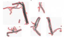
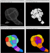
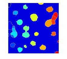
Watershed is the term that commonly refers to a mathematical morphology operation that treats a grayscale image as a topographic map and segments the image. The segmentation is performed by a succesive 'flooding' operation from minima in the image starting from different points and separates the image in different catchment basins.|Needs a comment about the relation between the Watershed and Region growing.

Synonyms
Watershed transformation
Watershed-based segmentation
Description

MorphoLibJ is a library of plugin for ImageJ with functionalities for image processing such as filtering, reconstructing, segmenting, etc... Tools are based on Mathematical morphology with more rigorous mathematical approach than in the standard tools of ImageJ in particular for surface (or perimeter) measurements which are usually based on voxel counting.  

http://imagej.net/MorphoLibJ#Measurements

Among the features:

Morphological operations :  Dilation, Erosion, Opening,  Closing , Top hat (white and black), Morphological gradient (aka Beucher Gradient), Morphological Laplacian, Morphological reconstruction, Maxima/Minima , Extended Maxima/Minima -Watershed (classic or controlled) -Image overlay -Image labelling -Geodesic diameter -Region Adjacency Graph -Granulometry curves, morphological image analysis.


several steps of morphological segmentation of plant tissue using MorphoLibJ.
Description

Adiposoft is an automated Open Source software for the analysis of adipose tissue cellularity in histological sections.

Example data can be found on the plugin description page in ImageJ wiki (download link). There is also a link to a MATLAB version of the workflow.

has topic
Description

A clear tutorial on how to write a MATLAB script to segment clustered cells.

The full script is downloadable near the bottom of the article. 

Description

A clear tutorial for splitting connected particles (cells) in a binary mask.

has function
Description

Marker-controlled Watershed is an ImageJ/Fiji plugin to segment grayscale images of any type (8, 16 and 32-bit) in 2D and 3D based on the marker-controlled watershed algorithm (Meyer and Beucher, 1990). This algorithm considers the input image as a topographic surface (where higher pixel values mean higher altitude) and simulates its flooding from specific seed points or markers. A common choice for the markers are the local minima of the gradient of the image, but the method works on any specific marker, either selected manually by the user or determined automatically by another algorithm. Marker-controlled Watershed needs at least two images to run: The Input image: a 2D or 3D grayscale image to flood, usually the gradient of an image. The Marker image: an image of the same dimensions as the input containing the seed points or markers as connected regions of voxels, each of them with a different label. They correspond usually to the local minima of the input image, but they can be set arbitrarily. And it can optionally admit a third image: The Mask image: a binary image of the same dimensions as input and marker which can be used to restrict the areas of application of the algorithm. Set to "None" to run the method on the whole input image. Rest of parameters: Calculate dams: select to enable the calculation of watershed lines. Use diagonal connectivity: select to allow the flooding in diagonal directions.

need a thumbnail